

Highlights
- Explore Bhutan with a cultural and trekking tour
- Visit the iconic Tiger's Nest Monastery
- Hike in the high Himalaya, up to 13,100 feet (4000 m)
- Experience the adventure of camping in the mountains
Brief Itinerary
| Day | Highlights | Overnight |
|---|---|---|
| Day 1 | Arrival in Paro and sightseeing | Paro |
| Day 2 | Haa Valley day tour | Paro |
| Day 3 | Hike to Taksang Monastery | Paro |
| Day 4 | Shana to Thangthangkha | Camping |
| Day 5 | Thangthangkha to Jangothang | Camping |
| Day 6 | Jangothang Halt | Camping |
| Day 7 | Jangothang to Lingshi | Camping |
| Day 8 | Lingshi to Shodu | Camping |
| Day 9 | Shodu to Barshong | Camping |
| Day 10 | Barshong to Dolam Kencho | Camping |
| Day 11 | Dolam Kencho to Dodena and Thimphu | Thimphu |
| Day 12 | Thimphu to Gangtey, Phobjikha Valley | Gangtey |
| Day 13 | Gangtey, Phobjikha Valley, local sightseeing & short hike | Gangtey |
| Day 14 | Gangtey to Punakha | Punakha |
| Day 15 | Punakha sightseeing & drive to Thimphu | Thimphu |
| Day 16 | Thimphu sightseeing | Thimphu |
| Day 17 | Depart (Thimphu to Paro, 1 hour drive) |
Detailed Itinerary
Day 1: Arrival in Paro, local sightseeing
Landing in the Paro Valley is a perfect entry into this other world of Bhutan, with its pure air and absorbing serenity. Paro retains its bucolic nature in spite of the existence of development projects. Fields of green and brown cover most of the valley floor, while hamlets and isolated farms dot the landscape.
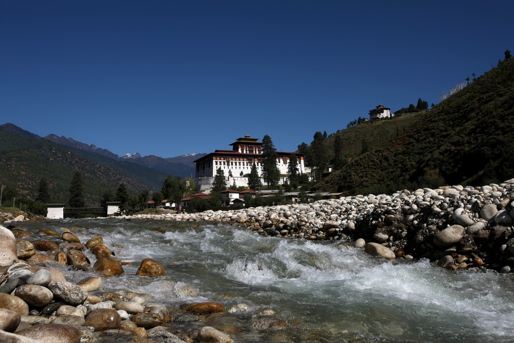
After lunch, visit the Paro Dzong (also called Rinpung Dzong), the 'Fortress of a Heap of Jewels'. Constructed in the early 15th century as a diminutive fort, it was developed into a much more commanding fortress in 1646. This is without a doubt one of the kingdom’s finest examples of traditional Bhutanese architecture.
On the return trip, cross a traditional wooden covered bridge called Nyamai-Zam, which spans the Paro River.
Day 2: Haa Valley day tour

Start early for the drive to Chele La, which at 13,083 feet (3988 m), is the highest road pass in Bhutan. It snakes upwards through blue pine and rhododendron forests for 21 miles (35 km). On a clear day, the view sweeps across to Bhutan’s second highest peak, Jhomolhari (23,996 feet / 7314 m), and down to the Haa Valley, which only opened to foreigners in 2002 due to its proximity to the border with Sikkim (India) and Tibet.
Passing along the Edelweiss-covered ridge, you will pass a sky burial site, the traditional Tibetan method of disposing of dead bodies. We then descend for the two-hour hike through dense rhododendron forest, possibly sighting shaggy yaks, to Kila Goemba, an ancient nunnery nestled in a craggy patch on the mountainside below.
Kila Goemba is a serene retreat for 32 Anim (Buddhist nuns) who lead an undisturbed life of religious studies, prayer, and meditation. The nunnery is one of the seven oldest nunneries in the Kingdom. It was established it in the early ninth century as a place for meditation. In 1986, the Government officially established Kila Goemba as an Anim Dratshang (nunnery). This sacred place has a timeless quality, which is ample reward for the effort of the hike. Having made your offerings and perhaps even been blessed, descend further. An hour later, you'll be back at the road.
For those who would prefer a leisurely sightseeing day, there is the option to drive from Chele La down the other side to the Haa Valley. In case Chele La is not accessible during the winter, your guide will propose an alternative for this day's excursion.
Haa (8759 feet / 2670 m) is the ancestral home of the Queen Grandmother and the illustrious Dorji family. Here, there are a couple of important temples and a few shops surrounded by farmhouses and apple orchards beside the fast-flowing Haa River. The hills of Haa provide an ideal location for hiking or mountain biking, with the chance to stop and visit remote shrines and temples and discover the unchanged lifestyles of nomadic herders.
Day 3: Hike to Taksang Monastery (aka the Tiger's Nest)

After breakfast, drive around 25 minutes to hike to one of Bhutan’s most revered pilgrimage sites, the Taktshang Lhakhang, popularly known as the Tiger’s Nest Monastery. The trek offers spectacular views of this sacred monastery perched precariously on a sheer rock face 2952 feet (900 m) above the valley floor. Legend has it that Guru Rinpoche, father of Mahayana Buddhism, arrived in the Paro Valley more than a millennium ago on the back of a tigress. He meditated for three months in a cave, which was converted into this monastery. The only sounds heard here are the murmurs of the wind, water, and the chanting of monks.
Begin the hike from the base to the cafeteria, which will take at least an hour and a half along well-maintained trails, and stop here for a rest. From here it’s about an hour’s trek through some stunning landscape to reach the monastery, which clings to a vertical rocky cliff. On your return, stop again at the cafeteria for lunch, then descend to the base of Ramthanka. The return hike takes around two hours.
In the evening, unwind with a traditional hot stone bath.
Day 4: Drive to Shana (9350 feet / 2850 m); Trek to Thangthangkha (11,843 feet / 3610 m)
Making an early start, drive to Shana. Stop en route at Drukgyel Dzong, a ruined fortress built in 1648 to control the northern route to Tibet. Leaving the road behind, follow the Pa Chhu River through rich farmland, past traditional farmhouses and the tiny settlements of Mitshi Zampa and Sangatang, before reaching the army checkpoint at Gunitsawa. After a short drive, you’ll reach Shana Zampa, where the trek begins.
Today's walk involves a long journey through rhododendron and the pine-clad river valley, entering Jigme Dorji National Park. Trekking through woodland and across many streams, you’re rewarded with spectacular views of Mt. Jhomolhari as you make your way to the meadow campsite at Thangthangkha (11,843 feet / 3610 m).
13 miles (21 km) | Drive 1-1.5 hours/ Walk 7-8 hours | 951 feet (290 m) ascent | Camp at 13,354 feet (4040 m)
Day 5: Thangthangkha (11,843 feet / 3610 m) to Jangothang (13,385 feet / 4080 m)

Although today is not a long trekking day, there will be a significant gain in altitude as you trek to above the tree line.
From the camp, your path ascends for a while until you reach the army camp. Then, follow the river above the tree line, enjoying the stunning view of the surrounding peaks along the way. Walk through a very muddy section of trail, pass a mani stone wall and enter yak country.
A hot lunch will be served inside a yak herder’s camp. After lunch, walk past the yak herder settlements of Soe and Takethang. Common crops grown here are barley, potatoes, and turnips. Walk across a plateau and up a stream bed to Dangochang village and the awesome campsite of Jangothang, at an altitude of 13,254 feet (4040 m). From here, the views of Mt. Jumolhari and Jichu Drake are superb.
11.8 miles (19 km) | 5-6 hours | 951 feet (290 m) ascent | Camp at 13,254 feet (4040 m)
Day 6: Jangothang Halt (13,385 feet / 4080 m)

Today, you will spend a day doing a four-hour acclimatization hike to the north of your camp. There is practically no trail but you will climb on an open slope until you see Mt. Jichu Drake (22,929 feet / 6989 m). You can scramble further up to 16,059 feet (4895 m), which is higher than Mont Blanc, for an amazing view of Mt. Jumolhari! You are likely to spot rare blue sheep, Himalayan rhubarb, griffon vultures, golden eagles and the remarkable blue poppy.
Jangothang base camp is flat grassy land with an old ruined fortress on a hillock beneath the colossal Jumolhari and Jichu Drake. Most people show some signs of mountain sickness at this altitude, and it is recommended that all trekkers halt here. You can also choose to simply relax at the camp today and preserve your energy.
5 miles (8 kms) | 4-5 hours | 2805 feet (855 m) ascent
Day 7: Jangothang to Lingshi
The trail leads to the last settlement in the valley and drops to the Paro Chhu. Passing the lake of Tshophu (14,370 feet / 4380 m) you will climb up steeply to Bhonte La pass (16,043 feet / 4890 m), the highest point of this trek. Reaching the Dhumzo Chhu river, trek downstream, passing the few houses of Soi Yaktsa (Dhumzo) to arrive at your camp soon after.
10 miles (16 km) | 6-7 hours | 2657 feet (810 m) ascent | 3576 feet (1090 m) descent | Camp altitude 12,467 feet (3800 m)
Day 8: Lingshi to Shodu
The Laya-Gasa route leaves the Jumolhari trek here. The trek route climbs towards a small white chorten (monument) on a ridge above the camp, then turns south up the deep Mo Chhu Valley. The trail stays on the west side of the largely treeless valley, climbing steadily a short distance above Mo Chhu. It then crosses the river, and climbs steeply for two hours to Yeli La (15,813 feet / 4820 m). From this pass, on a clear day you can see Jumolhari, Gangchen Ta, Tshering Gang and Masang Gang. Descend alongside a stream to a shelter, and then further downstream to a camp at Shodu (13,451 feet / 4100 m), a meadow with another chorten.
13.6 miles (22 km) | 8-9 hours | 2559 feet (780 m) ascent | 2362 feet (720 m) descent | Camp at 13,451 feet (4100 m)
Day 9: Shodu to Barshong

Here, you return to the tree line. The path follows Thimphu River, descending through rhododendron, juniper, and other alpine forests. The view of the cliff facing rocks and waterfalls is stunning. Hot lunch will be served by the riverside. After lunch, the trail gradually ascends to ruins beside the river, including the ruins of Barshong Dzong. The camp here is at an altitude of 12,139 feet (3700 m).
10 miles (16 km) | 5-6 hours | 1312 feet (400 m) descent | Camp altitude 12,139 feet (3700 m)
Day 10: Barshong to Dolam Kencho
The trail descends gently through a dense forest of rhododendron, birch, and conifers before dropping steeply to meet Thimphu Chhu. It stays on river left, climbing over ridges and descending to side streams. Then, it traverses a steep cliff to Dolam Kencho, a camp amid pastureland at 11,811 feet (3,600 m).
9.3 miles (15 km) | 5-6 hours | 328 feet (100 m) descent | Camp altitude 11,811 feet (3600 m)
Day 11: Dolam Kencho to Dodena and Thimphu

The trail goes in and out steeply to the river, and follows it southward to the road-head at Dodena (8530 feet / 2600 m). Here you will be picked up and driven to Thimphu.
5 miles (8 km) | 4-5 hours | 3280 feet (1000 m) descent
Day 12: Thimphu to Gangtey, Phobjikha Valley

Leaving Thimphu, head into the countryside towards the Gangtey Valley, home of the rare black-necked cranes. The drive ascends gradually to the Dochula Pass, with magnificent views of the Himalayas, where you'll stop in at the Dochula Monastery.
The descent to Wangduephodrang is vibrant and colorful, with fluttering prayer flags flying amid terraced farmland and rivers. Wangduephodrang is the last town on the highway before entering central Bhutan. Here, you can choose to stop at a viewpoint and see the ruins of the Wangdue Dzong, which was lost to fire but which is being rebuilt. Then, make your way towards the Phobjikha Valley, a wide glacial valley with a central stream that meanders through thickets of dwarf bamboo. The forest beyond the farms is mostly coniferous, and the general vegetation is composed largely of blue pine, birch, maple and several species of rhododendrons. Cranes migrate here in the winter.
Later in the afternoon, enjoy some traditional games. Bhutan’s national sport is dha (archery) which, along with khuru (darts), is the most popular sport in the country. Spend your evening at leisure in the hotel, or take a stroll in the with your guide to explore the fascinating glacier valley.
Day 13: Gangtey, Phobjikha Valley – local sightseeing & short hike

Today you'll be sightseeing in the Phobjikha Valley. Perched on a small hill rising from the valley floor, the Gangtey Monastery is surrounded by a large village, mainly inhabited by villagers who take care of the monastery. The Gangtey Monastery was founded in 1613, and the religious traditions of Pema Lingpa are still taught there. The monastery was rebuilt in the form of a Dzong in the late 17th to early 18th century.
Around the Phobjikha Valley, you can also enjoy the Gangtey Nature Trail. This pleasurable walk starts from the small hilltop overlooking Gangtey Goemba. Head downhill through flowering meadows to Simchubara village, and from here through beautiful forest and into the open valley. After passing Khewa Lhakhang, the trail ends at the Tabiding football ground. The nature trail can be combined with a visit to Gantey Goemba. If there's time, you can cycle around the valley.
Day 14: Gangtey to Punakha

Leave Gangtey after an early breakfast and travel towards the Punakha Valley, the winter capital of Bhutan. In Punakha, walk through paddy fields to Pana Village to see the Chimi Lhakhang temple, built in 1400 to subdue local demons. The temple is a popular pilgrimage point for Bhutanese people and is especially revered by women for its fertility powers.
After lunch, visit the historic Punakha Dzong, which is located at the confluence of the Phochu (male) and Mochu (female) rivers. It was built in 1637 and serves as the winter residence of the head abbot, Je Khenpo, and headquarters of the district administration.
Day 15: Punakha Sightseeing & drive to Thimphu
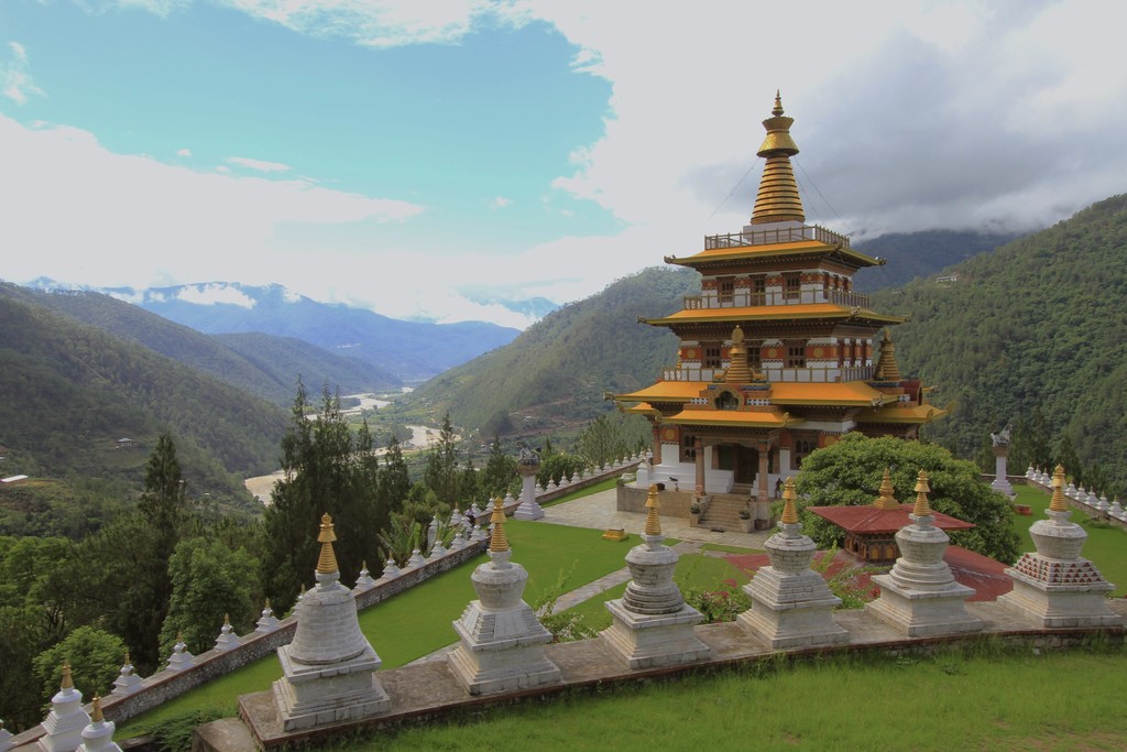
After an early breakfast, set out on a beautiful day hike to Khamsum Yulley Namgyal Monastery. A thirty-minute drive from Punakha Dzong will bring you to the base of the hill on which this temple is built. From the car park, cross a suspension bridge and walk through rice fields before climbing a moderate incline surrounded by pine trees. The hike up is about an hour, and down about half an hour. Enjoy the serene natural beauty of the area and light traditional butter lamps at the temple - a powerful offering symbolizing wisdom.
After the hike, drive onwards to Thimphu (three hours), stopping at the Dochula Pass to take photographs and hang prayer flags.
Day 16: Thimphu sightseeing

Begin a day of exploring Thimphu at the Memorial Chorten, with its golden spires shining in the sun, its tinkling bells and an endless procession of elderly people circling around it. Later, visit Kuensel Phodrang, where the Buddha Dordenma resides. It is said to be one of the largest Buddhas in the world, standing at 169 feet (51.5 m). You will get a bird's eye view of Thimphu from here.
Head to the nearby Happiness Garden to plant a tree here in your family's name. The Happiness Garden is dedicated to the birth of His Royal Highness The Gyalsey (Prince of Bhutan), and to the conservation of Mother Nature. After lunch, visit the Folk Heritage Museum, which will give you a glimpse into the traditional Bhutanese lifestyle. There is an impressive collection of typical household objects, tools, and equipment. The museum also organizes regular demonstrations of rural traditions, skills, and customs, and hosts educational programs for children. Next, visit the Vast Art Gallery, the capital's main center for local artists. It's a great place to plug into the Thimphu art scene, check out the latest exhibits, and chat with artists.
Take a walk through the town and visit the many textile and handicrafts shops that line the streets of Thimphu or even visit the newly opened Craft Bazaar. This is an initiative of the Royal Government of Bhutan, to open stalls for local craftspeople to display products that are only made in Bhutan.
Day 17: Depart from Paro

After breakfast, drive from Thimphu to Paro, an hour away. Depart from Paro Airport.
Map
